MAP OF BAR ISLAND - ACADIA NATIONAL PARK THE BEAR'S DEN Way back before the great fire of 47, back when Bar Harbor was named Eden, there was a popular trail that lead from the village to a place on the side of champlain Mountain known as the Bear's Den. This was long before there was ever a Park Loop road or a a National Park here for that matter.
Back than there was a very real bear population on Mount desert Island, and a number of the bears called the caves on Champlain Mountain their homes.
Once the National Park was formed and the Park Loop Road built, a large section of the Bear's Den trail was destroyed and it was thought the location of the Bear's Den was lost as well. Through a lot of research and searching the area, we were able to find the location, and soon I had made a map to it as well. The thing that surprised me the most was that it had been right there for many years, hiding in plain site. I say this because if your on the side of the Park Loop Road's One Way section, at just the right spot, and turn to look into the woods you can see the opening of the Bear's den. 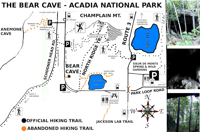
The den is large enough for you to enter and kneel down to have your picture taken.
To reach the Bear's Den, you need to be on the Park Loop road - the one way section. Continue past the turn off for Sieur de Monts Spring, pass under the stone bridge, and up around the curve leading uphill. Now drive ato the end of the stretch of roadway ahead, to a parking area at the sharp curve ahead - you will pass a small pond on the right as you drive along.
Get out of your car and cross the roadway and walk a short ways heading with the flow of traffic, to where the rock ledge slopes down to meet the woods. Right there is where you want to look into the woods from the roadside to see the Bear's Den. A worn path leads to it and it makes for a great photo.
Don't worry about disturbing any bears, the park service had a program in place for many years removing bears from the island. The program is no longer in place, but most bear sightings are at dusk on the quiet side of the island.
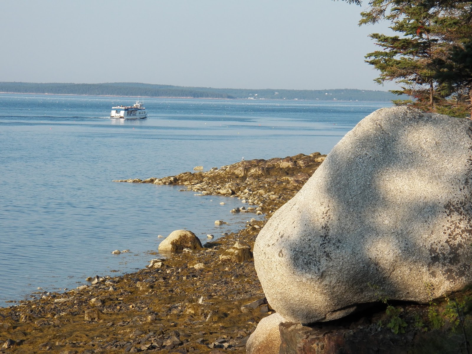
COMPASS HARBOR Compass Harbor is very hard to locate and it is meant to be that way, the Park Service would rather people not find it. Compass Harbor is in Acadia National Park, yet a short ways from downtown Bar Harbor on the far end of Main Street as your leaving town. It is treated by the Park Service the same way they treat their abandoned trails, unmark. Tree's and brush serve to help conceal the very tiny parking lot from route 3. Even the trail head in the far corner of the parking lot is unmarked.
The Park Service has stated they consider that area to have historic value, and right they should. It was the site of Old Farm - the George B. Dorr estate, he often being called the Father of Acadia. If not for his efforts there most likely would never of been a National Park in Maine.
Compass Harbor has not one but two beaches and the Compass Harbor trail does a nice loop through the entire area.
First I will begin at the start of the trail, it runs a short distance through deep woods before coming to an intersection - go left. After passing a short ways through more forest, you come to the ocean and the first beach. Expect to see people below searching for shells or sea life, there are several narrow paths that lead down to the waters edge.
Here the main path turns right follows the oceans edge before turning right again, but here you have an option fo a path which leads straight ahead through brush. This path leads out to a point of granite known as Lookout Point.
Back on the main path - continue straight ahead a short ways, the main path turns right again and there is what appears to be a never ending set of stone steps leading through the woods and straight up a hill - more on that in a bit.
Your other option here is to go straight ahead a very short ways where you will come to a very high cliff overlooking a very nice beach below. Many of the locals come to this beach on a hot after noon, and in the evening there is often someone nearby playing an instrument or two. Just to the left there is a short path leading out to the rocks along the waters edge, and from there you can easily reach the beach.
Back on the main trail, continue through the woods along the stone steps, it will take you to the top of the hill where you will pass through the remains of Old Farm. Don't expect to find George there offering you a cup of tea, him and his estate passed away many years ago, but you can search the area for other foundations, sections of stone work from his once famous gardens, and such.
Once your done exploring the area continue on a short ways back to the parking lot.
Now how to find the parking lot to reach Compass Harbor in the first place. Begin on Main Street in Downtown Bar Harbor. You want to drive down Main Street, and head toward Otter Creek along route 3. This will take you past the Bar Harbor YMCA and the Bar Harbor Ball fields. You will than drive round a curve and head down a long stretch of roadway that will begin to head uphill, just before the road begins to head uphill, begin to look for that tiny unmarked parking lot on the left hand side of the roadway. If you reached Schooner Head road or Jackson Labs - you passed it. ANEMONE CAVE - THE DIVIL'S OVEN First off, Anemone Cave was abandoned by the National Park service years ago, so it is un marked, all signs telling of it have been taken down, and the iron railing that once helped get visitors safely down to the cave's entrance has been removed.
There are a number of reasons this happened, there are stories of people entering the cave at the wrong time and getting caugh inside by crashing waves from an incoming tide, their bodies being carried out to sea. Other stories tell of countless injuries from people falling off of the slippery cliffs. And at least one old map has the ancient sea cave listed as THE DIVIL'S OVEN - most likely as the result of past deaths that hace occurred there. The Park service says it was because of injuries, and because they had to rescue people caught in the cave, as well as to protect the sea life which lives in the tidal pools in the cave itself. No matter, the fact is this ancient sea cave was abandoned by the park and if you chose to visit it, you are pretty much on your own at getting down the cliff to the cave entrance.
Many go the way the real path went, to the right and downward. If you look at the granite on the cliff you can stillsee where the iron rails were cut away.
That approach is the quickest but steepest approach to the cave entrance. Others head along the top of the cliff a ways until they come to a long gully that runs back toward the entrance of the cave. 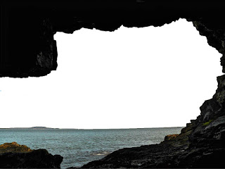
I really have to add a word of caution here, without that iron railing to help you down, regardless of which approach you take, both can be very dangerous. The granite is usually wet and in this area wet granite usually means very slippery granite. Once you reach the entrance of the cave, you are confronted by extremely slippery seaweed - one worng step could turn a really good day into a really bad day. The entire inside of the cave is covered with this extremely slippery seaweed, so do use caution and proceed slowly. My best advice is to wear a very good hiking boot and maybe even some type of ice cleats what help you to stay on your feet in icy weather. You should be okay if you go real slow and test each step.
To locate this now abandoned sea cave, you first need to reach the Schooner Head Overlook parking lot. Drive down the Schooner Head road until you come to a four way intersection, the parking lot is to your left.
If on the Park Loop road one way section, drive until you approach the entrance fee station - but do not drive up to it, instead take that left right before the fee station. This will take you to a four way intersection just ahead. Continue straight ahead into the parking area.
If you want to reach the sea cave by means of the free Island Explorer bues, at the Bar Harbor Village Green board the number 5 Sand Beach bus. Tell the driver you want to get off the bus at the park entrance fee station on the park loop road. Once off the bus, head down that road by the fee station to the intersection and continue straight ahead into the parking area.
Near the center of the parking lot is some sort of sign, and by the sign is a narrow paved path, walk down that path until you come to the cliffs. At this point you are actially standing on the roof of the cave. If you move out onto the cliff and towards the right you can look downward and see the cave entrance, providing the tide is right.
In order to enter the cave and explore, you need to be there at least one hour before the low tide mark and be out of there one hour past the low tide mark. Remember that the tide rises a lot faster than you may think, and you can go from no waves to little waves outside the cave to powerful crashing waves sweeping into the cave in a short period of time. That is perhaps the main reason the park decided to abandon the site.
THE OLD STONE TOWER The Stone tower was once part of the filtering system for the Bar Harbor Water company. It's an empty rock tower with a large section of pipe passing through the top of it. Years ago it use to be boarded up, but the plywood has long since been removed.
A search of the ground will reveal the top section of a very large pipe leading away from the tower. Behine the tower is an old overgrown road that follows pretty much the banks of Duck Brook, the water usually flows pretty quickly along there and can make for some nice photo taking.
When you first enter the woods from the main road, if you go down to the right, you come to two very large foundations, these were actually huge sand fillering systems. Further in the woods is remains of a third filtering system. I don't know why but people who do diiscover it, like to go there to have their photo taken next to the tower. 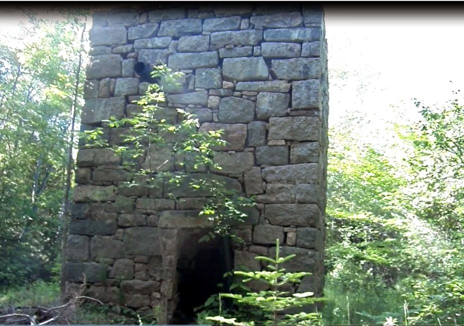
To locate the Stone Tower, you need to drive from Bar Harbor down Mount desert Street and along route 233 - the Eagle Lake road. Pass under the large arched stone bridge and continue on for a ways, until you come to a road on the right AFTER the bridge, it is marked Duck Brook Bridge Road.
Turn onto that road and park at the corner. Walk back to the Eagle Lake road and cross the small bridge with the guardrails. Right after that begin looking for an old dirt road leading into the woods, it will be right there after the guard rails.
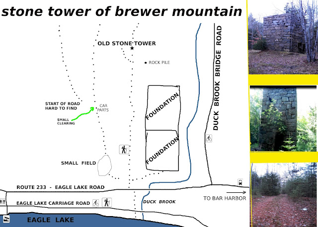
To reach and explore the area around the filtering system foundations, go right after entering the woods.
To reach the Stone tower, continue straight ahead until you come to a small field, the Tower rises up out of the field.
COMPASS HARBOR - GEORGE B. DORR ESTATE
Compass Harbor is very hard to locate and it is meant to be that way, the Park Service would rather people not find it. Compass Harbor is in Acadia National Park, yet a short ways from downtown Bar Harbor on the far end of Main Street as your leaving town. It is treated by the Park Service the same way they treat their abandoned trails, unmark. Tree's and brush serve to help conceal the very tiny parking lot from route 3. Even the trail head in the far corner of the parking lot is unmarked.
The Park Service has stated they consider that area to have historic value, and right they should. It was the site of Old Farm - the George B. Dorr estate, he often being called the Father of Acadia. If not for his efforts there most likely would never of been a National Park in Maine.
Compass Harbor has not one but two beaches and the Compass Harbor trail does a nice loop through the entire area.
First I will begin at the start of the trail, it runs a short distance through deep woods before coming to an intersection - go left. After passing a short ways through more forest, you come to the ocean and the first beach. Expect to see people below searching for shells or sea life, there are several narrow paths that lead down to the waters edge.
Here the main path turns right follows the oceans edge before turning right again, but here you have an option fo a path which leads straight ahead through brush. This path leads out to a point of granite known as Lookout Point.
Back on the main path - continue straight ahead a short ways, the main path turns right again and there is what appears to be a never ending set of stone steps leading through the woods and straight up a hill - more on that in a bit.
Your other option here is to go straight ahead a very short ways where you will come to a very high cliff overlooking a very nice beach below. Many of the locals come to this beach on a hot after noon, and in the evening there is often someone nearby playing an instrument or two. Just to the left there is a short path leading out to the rocks along the waters edge, and from there you can easily reach the beach. 
Back on the main trail, continue through the woods along the stone steps, it will take you to the top of the hill where you will pass through the remains of Old Farm. Don't expect to find George there offering you a cup of tea, him and his estate passed away many years ago, but you can search the area for other foundations, sections of stone work from his once famous gardens, and such.
Once your done exploring the area continue on a short ways back to the parking lot.
Now how to find the parking lot to reach Compass Harbor in the first place. Begin on Main Street in Downtown Bar Harbor. You want to drive down Main Street, and head toward Otter Creek along route 3. This will take you past the Bar Harbor YMCA and the Bar Harbor Ball fields. You will than drive round a curve and head down a long stretch of roadway that will begin to head uphill, just before the road begins to head uphill, begin to look for that tiny unmarked parking lot on the left hand side of the roadway. If you reached Schooner Head road or Jackson Labs - you passed it.
THE MYSTERIOUS ROCKS OF LITTLE HUNTER'S BEACH Little Hunter's Beach seems to also have joined the long and growing list of abandoned places in Acadia National Park. The Little Hunter's brook Trail also seems to have vanished off maps. If you have never been to Little Hunter's Beach than you have missed out on a unique spot within the park.
It is not a sand beach, it is a rock beach, and a small one at that. What makes it such a unique place is it is located in a small cove where the waves come crashing in, which over the years acts much like a rock tumbler, causing many of the stones there to be either perfectly round or perfectly oval shaped. Some clam the perfectly round and oval stones hold unexplained healing properties inherited from the powerful waves that give the stones their unique shapes.
When I passed by there last year I noticed the beach no longer had a sign marking it and checked a current map and saw it no longer listed. In fact, its bigger sister, Hunter's Beach, further up the road, was also missing from the map. 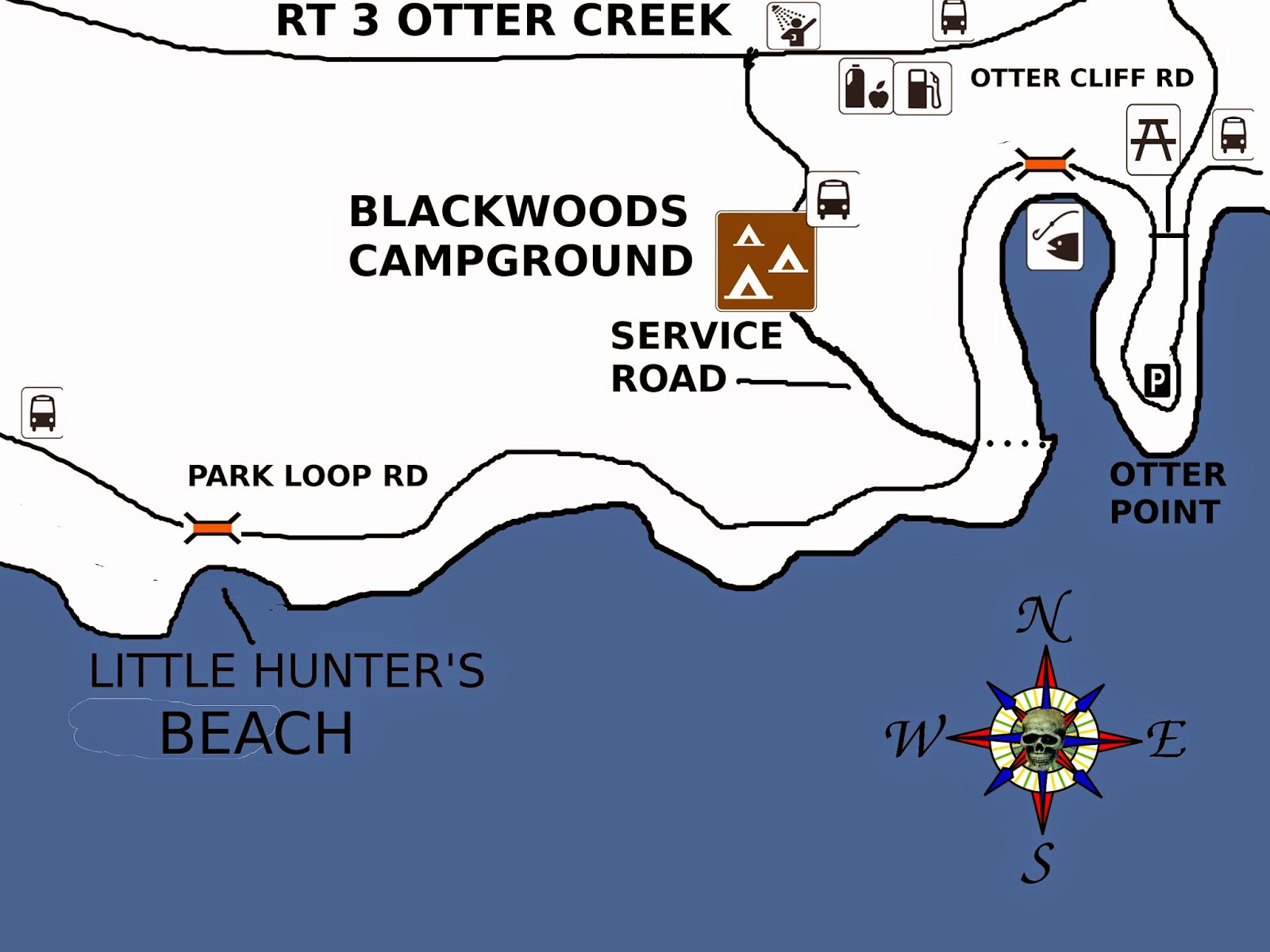 | | Map of Little Hunter's Beach - Acadia National Park |
So how do you locate Little Hunter's Beach, it's easy, but you will have to be alert for the things to look for.
Drive along the One Way section of the Park Loop road, past the popular Sand Beach and Thunder Hole. Continue past the Fabbri picnic area, and you will soon cross a stone bridge. Here the road climbs up hill, and you will soon pass the service entrance to Blackwoods Campground, there will be a cross walk and a wooden fence on the left. Now drive on for some distance still, but keep looking for a small stone bridge you will come to. Pull over before the small bridge, and on the left hand side of the road there will be a long wooden stairway leading to the beach.
The Little Hunter's Brook Trail head use to be on the other side of the road, by one corner of the bridge.
MAPS OF ACADIA NATIONAL PARK |